Texas State Intermediate Thematic Wall Map on Roller w/ Backboard
Desertcart purchases this item on your behalf and handles shipping, customs, and support to Morocco.
Description
- Laminated for Use with Dry-Erase or water-soluble Markers. (not included)
- Wall Map is mounted on Spring Roller with Backboard for Easy Retraction.
- Map hanging hardware needed? Click for Accessrories
- Exceeds State Standards and Curriculum Framework!
- Width 64, Height 54
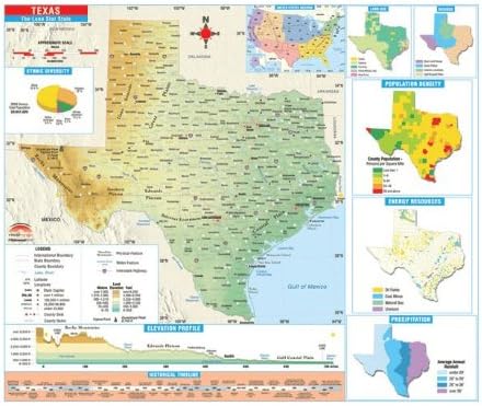
The Texas State Intermediate Thematic Wall Map is the perfect teaching aid for state studies and related subjects. Political/physical maps with hypsometric colorations; shows county boundaries, interstate highways, county seats, cities and towns and state regions. Maps correlate with state standards and curriculum guidelines. They are constructed of heavy paper, with a write-on/wipe-off laminated finish that can be used with water-based or dry erase pens. Mounted on spring roller with backboard. Primary Thematic Wall Maps feature a historical timeline and elevation profile, plus insets of land use, ethnic diversity, and population, average precipitation, and more. Measures 64 in. x 54 in. and corresponds with the Thematic Deskpad Maps. Two-sided with markable/washable finish makes it ideal for student testing. This map is ideal for school use in public school, private school, parochial school, and home school's classrooms.
Common Questions
Trustpilot