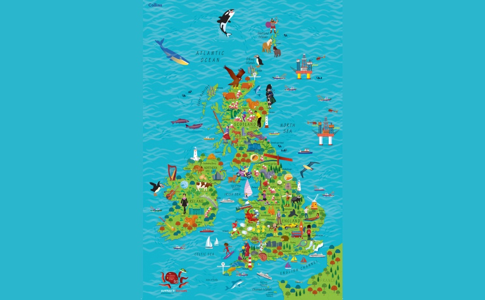
Collins Children’s Wall Map of the United Kingdom and Ireland
S**N
Fun and educational
Fun and educational map of the UK and Ireland. My 5 and 8 year olds both like this map and has learnt a lot from it with help from me. We sometimes play little games to see if they can find cities and pictures in it. It has a variety of illustrations and quite a few cities. A map on a wall is a much more powerful educational tool than an Atlas on a bookshelf. The map is cellofane wrapped rather than in a cardboard tube but mine arrived without any damage.There is quite a bit of sea on the map but the map has both Britain and Ireland and all the way up to Shetland Islands. So I think it's difficult to avoid that.There are 14 men and 4 women. I don't think there is any bias here. It's just that Shakespeare, Robin Hood and King Arthur etc are men.It does have a barcode printed on the bottom left corner in vertical orientation. This may bother some although I think it's lot less noticeable than the barcode printed on the Collins World map which we also have.Here is a list of some of the illustrations: Shakespeare, Robin Hood, King Arthur and the Excalibur, Stonehenge, Eden project, Cornish pasties, Angle of the north, Isle of Man TT, Manx cat, Highland cattle, Snowdon mountain railway, Blackpool tower, the Open golf, Wimbledon, Cricket (Lord's/Oval), Rugby (Wales), Red/White rose (Lancashire/Yorkshire), punting in Cambridge, Kilns in Stoke-on-trent, Welsh dragon, giant causeway and more.We all rely on good reviews for online shopping. So if this review was helpful please let me know by clicking the helpful button.
B**T
OK, but not as good as world map
Got the Children’s world map recently and my kids love it and look at it every night where I set them challenges on what to find, so I thought I’d get the U.K. map too. Unfortunately it’s not got as much of interest on it and there are vast areas of just blue sea, and within the countries there’s not nearly as many things to spot as in the world map. Pity, because it has so much potential. Maybe they should make the pictures they use smaller so there’s more room for other interesting things. They could include the counties on there too to make it more interesting and useful maybe.
B**S
Good product but packaging OTT
I've bought this for my young nephew to give him some idea of where he lives, Kent, and where I live North Wales. I decided to add all the family members to it too but could have done with a few more Counties/County towns on it as my geography isn't that great. All in all though a good product. However the packaging was so over the top as to be laughable. The box was 46" long for a poster that was only 24" !
C**S
Making learning fun.
Another wall map for the grandchildrens' bedroom. They have an interest in the different countries of the world and of the UK so we are encouraging that interest at a time when they are thirsty for knowledge.
L**G
Good interactive map of the UK and Ireland
My nephews and niece love this wall map of the UK and Ireland. The map is coloruful with lots of different images of animals, flora and fauna and of people, these images represent different parts of the UK etc. Some reviewers were upset that there were not many female images - I don't think this is an issue. Overall this has been a good buy, its educational and fun.
ترست بايلوت
منذ 3 أسابيع
منذ يوم واحد